3D transformation of rasters using GDAL and proj libraries
- The goal of this notebook is to perform 3D CRS transformations using the command line utility gdalwarp
- Examples of 3DEP DEM, SRTM DEM, and Copernicus DEMs are provided
This tutorial stemmed from the ICESat-2 2023 Hackweek 3D CRS breakout group led by David Shean. It uses notes and gotchas on package imports from the notebook shared by Scott Henderson.
Prepared by: Shashank Bhushan, August 15, 2023
TODO: Add example of 3DEP LiDAR 3D transformation
Setup: Package installs and imports
# From Scott's notebook (https://github.com/ICESAT-2HackWeek/3D_CRS_Transformation_Resources/blob/main/geopandas3D.ipynb)
# NOTE: REQUIRES PROJ>=9.2 and GEOPANDAS>=0.13

!pip install geopandas==0.13 #geopandas is not required for this particular tutorial
Collecting geopandas==0.13
  Downloading geopandas-0.13.0-py3-none-any.whl (1.1 MB)
     ━━━━━━━━━━━━━━━━━━━━━━━━━━━━━━━━━━━━━━━━ 1.1/1.1 MB 7.8 MB/s eta 0:00:00:00:0100:01
Requirement already satisfied: shapely>=1.7.1 in /srv/conda/envs/notebook/lib/python3.10/site-packages (from geopandas==0.13) (2.0.1)
Requirement already satisfied: fiona>=1.8.19 in /srv/conda/envs/notebook/lib/python3.10/site-packages (from geopandas==0.13) (1.9.4)
Requirement already satisfied: packaging in /srv/conda/envs/notebook/lib/python3.10/site-packages (from geopandas==0.13) (23.1)
Requirement already satisfied: pyproj>=3.0.1 in /srv/conda/envs/notebook/lib/python3.10/site-packages (from geopandas==0.13) (3.6.0)
Requirement already satisfied: pandas>=1.1.0 in /srv/conda/envs/notebook/lib/python3.10/site-packages (from geopandas==0.13) (1.5.1)
Requirement already satisfied: click~=8.0 in /srv/conda/envs/notebook/lib/python3.10/site-packages (from fiona>=1.8.19->geopandas==0.13) (8.1.6)
Requirement already satisfied: certifi in /srv/conda/envs/notebook/lib/python3.10/site-packages (from fiona>=1.8.19->geopandas==0.13) (2023.5.7)
Requirement already satisfied: attrs>=19.2.0 in /srv/conda/envs/notebook/lib/python3.10/site-packages (from fiona>=1.8.19->geopandas==0.13) (21.4.0)
Requirement already satisfied: cligj>=0.5 in /srv/conda/envs/notebook/lib/python3.10/site-packages (from fiona>=1.8.19->geopandas==0.13) (0.7.2)
Requirement already satisfied: six in /srv/conda/envs/notebook/lib/python3.10/site-packages (from fiona>=1.8.19->geopandas==0.13) (1.16.0)
Requirement already satisfied: click-plugins>=1.0 in /srv/conda/envs/notebook/lib/python3.10/site-packages (from fiona>=1.8.19->geopandas==0.13) (1.1.1)
Requirement already satisfied: python-dateutil>=2.8.1 in /srv/conda/envs/notebook/lib/python3.10/site-packages (from pandas>=1.1.0->geopandas==0.13) (2.8.2)
Requirement already satisfied: pytz>=2020.1 in /srv/conda/envs/notebook/lib/python3.10/site-packages (from pandas>=1.1.0->geopandas==0.13) (2023.3)
Requirement already satisfied: numpy>=1.21.0 in /srv/conda/envs/notebook/lib/python3.10/site-packages (from pandas>=1.1.0->geopandas==0.13) (1.23.5)
Installing collected packages: geopandas
  Attempting uninstall: geopandas
    Found existing installation: geopandas 0.12.1
    Uninstalling geopandas-0.12.1:
      Successfully uninstalled geopandas-0.12.1
Successfully installed geopandas-0.13.0
import os
os.environ['USE_PYGEOS'] = '0'
os.environ['PROJ_DEBUG'] = '2' # For showing logs
#os.environ['PROJ_NETWORK'] = 'ON' # Ensure this is 'ON' to get shift grids over the internet
print(os.environ['PROJ_NETWORK'])

import fiona
import geopandas as gpd
import shapely
import rasterio
import rioxarray
import matplotlib.pyplot as plt
#https://xyzservices.readthedocs.io/en/stable/introduction.html
import xyzservices
ON
gpd.show_versions()
SYSTEM INFO
-----------
python     : 3.10.12 | packaged by conda-forge | (main, Jun 23 2023, 22:40:32) [GCC 12.3.0]
executable : /srv/conda/envs/notebook/bin/python
machine    : Linux-5.10.167-147.601.amzn2.x86_64-x86_64-with-glibc2.27

GEOS, GDAL, PROJ INFO
---------------------
GEOS       : 3.11.2
GEOS lib   : None
GDAL       : 3.7.0
GDAL data dir: /srv/conda/envs/notebook/share/gdal
PROJ       : 9.2.1
PROJ data dir: /srv/conda/envs/notebook/share/proj

PYTHON DEPENDENCIES
-------------------
geopandas  : 0.13.0
numpy      : 1.23.5
pandas     : 1.5.1
pyproj     : 3.6.0
shapely    : 2.0.1
fiona      : 1.9.4
geoalchemy2: None
geopy      : None
matplotlib : 3.6.2
mapclassify: 2.5.0
pygeos     : 0.14
pyogrio    : None
psycopg2   : 2.9.6 (dt dec pq3 ext lo64)
pyarrow    : 12.0.1
rtree      : 1.0.1
### Setup opentopography Global DEM download package! git clone https://github.com/uw-cryo/opentopo_dem.gitCloning into 'opentopo_dem'...
remote: Enumerating objects: 35, done.
remote: Counting objects: 100% (35/35), done.
remote: Compressing objects: 100% (28/28), done.
remote: Total 35 (delta 17), reused 14 (delta 6), pack-reused 0
Receiving objects: 100% (35/35), 10.78 KiB | 581.00 KiB/s, done.
Resolving deltas: 100% (17/17), done.
Study Site
We will explore 3D CRS transformation at Grand Mesa, located in Colorado, USA
aoi_fn = 'grandmesa.geojson' #we are going to use Grand Mesa as our example study site
gdf = gpd.read_file('grandmesa.geojson')
terrain_map = xyzservices.providers.Esri.WorldImagery()
gdf.explore(tiles=terrain_map)
Loading...
Example 1: SRTM
- The original SRTM product is provided in geographic coordinate system (EPSG:4326), with heights relative to the EGM96 Geoid.
- We will attempt to transform it to UTM 12 N horizontal CRS, with heights relative to the WGS84 ellipsoid
- We will download data on the fly from the opentopography api.
Note that the opentopography api also provides a SRTM product which already accounts for heights relative to WGS84 ellipsoid,which we will also use as validation
srtm_gl1_geo_fn = 'grandmesa_SRTM_GL1_epsg4326.tif'
utm_proj = 'EPSG:32612'
! opentopo_dem/download_global_DEM.py -demtype SRTMGL1 -poly_fn $aoi_fn -out_fn $srtm_gl1_geo_fn[-108.27777581191845, 38.88692329848007, -108.03091154046082, 39.10042883419405]
https://portal.opentopography.org/API/globaldem?demtype=SRTMGL1&west=-108.27777581191845&south=38.88692329848007&east=-108.03091154046082&north=39.10042883419405&outputFormat=GTiff&API_Key=demoapikeyot2022
OK!
Script is complete
Projection change information
- Information on ESPG code for vertical datums can be found here
- Input CRS: EPSG:4326+5773 (Geographic horizontal CRS, with heights relative to EGM96 Geoid)
- Output CRS: EPSG:32612+4979 (UTM 12 N horizontal CRS, with heights relative to WGS84 ellipsoid)
# check transformation steps using projinfo command
! projinfo -s EPSG:4326+5773 -t EPSG:32612+4979 -o PROJ --hide-ballpark --spatial-test intersects
pj_open_lib(proj.ini): call fopen(/srv/conda/envs/notebook/share/proj/proj.ini) - succeeded
pj_open_lib(proj.db): call fopen(/srv/conda/envs/notebook/share/proj/proj.db) - succeeded
pj_open_lib(us_nga_egm96_15.tif): call fopen(/home/jovyan/.local/share/proj/us_nga_egm96_15.tif) - succeeded
pj_open_lib(us_nga_egm96_15.tif): call fopen(/home/jovyan/.local/share/proj/us_nga_egm96_15.tif) - succeeded
Candidate operations found: 1
-------------------------------------
Operation No. 1:

pj_open_lib(us_nga_egm96_15.tif): call fopen(/home/jovyan/.local/share/proj/us_nga_egm96_15.tif) - succeeded
unknown id, Inverse of WGS 84 to EGM96 height (1) + UTM zone 12N, 1 m, World.

PROJ string:
+proj=pipeline
  +step +proj=axisswap +order=2,1
  +step +proj=unitconvert +xy_in=deg +xy_out=rad
  +step +proj=vgridshift +grids=us_nga_egm96_15.tif +multiplier=1
  +step +proj=utm +zone=12 +ellps=WGS84
output_srtm_reprojected_fn = 'grandmesa_SRTM_GL1_epsg32612_wgs84ellipsoid.tif'!gdalwarp -s_srs EPSG:4326+5773 -t_srs EPSG:32612+4979 -tr 30.0 30.0 -r bilinear $srtm_gl1_geo_fn $output_srtm_reprojected_fnCreating output file that is 737P x 813L.
Processing grandmesa_SRTM_GL1_epsg4326.tif [1/1] : 0Using internal nodata values (e.g. -32768) for image grandmesa_SRTM_GL1_epsg4326.tif.
Copying nodata values from source grandmesa_SRTM_GL1_epsg4326.tif to destination grandmesa_SRTM_GL1_epsg32612_wgs84ellipsoid.tif.
...10...20...30...40...50...60...70...80...90...100 - done.
Check if the transformation worked
input_srtm_egm96 = rioxarray.open_rasterio(srtm_gl1_geo_fn)
output_srtm_reprojected = rioxarray.open_rasterio(output_srtm_reprojected_fn)output_srtm_reprojected.rio.crsCRS.from_epsg(32612)input_srtm_egm96.rio.crsCRS.from_epsg(4326)output_srtm_reprojected.spatial_refLoading...
input_srtm_egm96.spatial_refLoading...
diff = output_srtm_reprojected - input_srtm_egm96.rio.reproject_match(output_srtm_reprojected,resampling=rasterio.enums.Resampling.bilinear)
f,ax = plt.subplots()
diff.plot(vmin=-30, vmax=30, cmap="RdBu",ax=ax)
ax.set_title(f"Median difference after datum change (EGM96Geoid -> WGS84): {diff.median().item():.2f} m")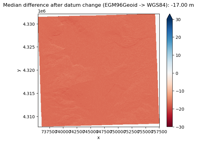
We see that due to transformation of heights from EGM96 Geoid to WGS84 ellipsoid, there is a median height change of -17 m, which makes sense based on Grand Mesa’s location.
Sanity Check: Now we will download the SRTM DEM with heights relative the WGS84 ellipsoid from the opentopography api, and compare to our 3D transformed output from above
srtm_gl1_ellipsoidal_fn = 'grandmesa_SRTM_GL1_E.tif'
! opentopo_dem/download_global_DEM.py -demtype SRTMGL1_E -poly_fn $aoi_fn -out_fn $srtm_gl1_ellipsoidal_fn
[-108.27777581191845, 38.88692329848007, -108.03091154046082, 39.10042883419405]
https://portal.opentopography.org/API/globaldem?demtype=SRTMGL1_E&west=-108.27777581191845&south=38.88692329848007&east=-108.03091154046082&north=39.10042883419405&outputFormat=GTiff&API_Key=demoapikeyot2022
OK!
Script is complete
input_srtm_ellipsoidal = rioxarray.open_rasterio(srtm_gl1_ellipsoidal_fn)
diff_srtm_ellipsoidal_output_reproj = output_srtm_reprojected - input_srtm_ellipsoidal.rio.reproject_match(output_srtm_reprojected,resampling=rasterio.enums.Resampling.bilinear)
f,ax = plt.subplots(1,2)
diff_srtm_ellipsoidal_output_reproj.plot(vmin=-30, vmax=30, cmap="RdBu",ax=ax[0])
diff_srtm_ellipsoidal_output_reproj.plot(vmin=-10, vmax=10, cmap="RdBu",ax=ax[1])
f.suptitle(f"Median difference between default SRTM Ellipsoidal Heights DEM from opentopography and \n ours earlier 3D reprojected one : {diff_srtm_ellipsoidal_output_reproj.median().item():.2f} m")
plt.tight_layout()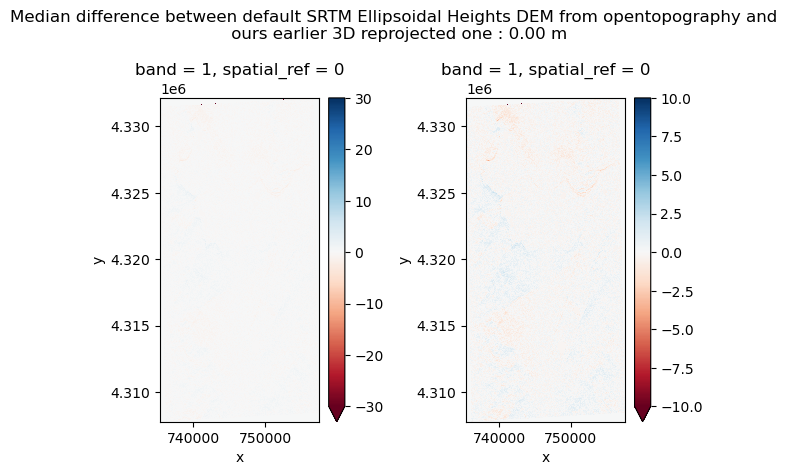
Voila! We see that the difference between OpenTopography default’s ellipsoidal heights and our 3D tranformed ellipsoidal height DEM is close to zero, which gives confidence in our conversion. It is not exactly zero though, and we still do observe some residual differences in the plot on the left with colorbars stretched from -10 to 10. This brings out the tricky differences coordinate transformations can bring!
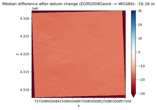
Example 2: Copernicus Global 30 m DEM
- The original Copernicus DEM product is provided in geographic coordinate system (EPSG:4326), with heights relative to the EGM2008 Geoid.
- We will attempt to transform it to UTM 12 N horizontal CRS, with heights relative to the WGS84 ellipsoid
- As in example 1, we will download data on the fly from the opentopography api.
copdem_geo_fn = 'grandmesa_COPDEM_epsg4326.tif'
! opentopo_dem/download_global_DEM.py -demtype COP30 -poly_fn $aoi_fn -out_fn $copdem_geo_fn
[-108.27777581191845, 38.88692329848007, -108.03091154046082, 39.10042883419405]
https://portal.opentopography.org/API/globaldem?demtype=COP30&west=-108.27777581191845&south=38.88692329848007&east=-108.03091154046082&north=39.10042883419405&outputFormat=GTiff&API_Key=demoapikeyot2022
OK!
Script is complete
Projection change information
- Information on ESPG code for vertical datums can be found here
- Input CRS: EPSG:4326+3855 (Geographic horizontal CRS, with heights relative to EGM96 Geoid)
- Output CRS: EPSG:32612+4979 (UTM 12 N horizontal CRS, with heights relative to WGS84 ellipsoid)
# check transformation steps using projinfo command
! projinfo -s EPSG:4326+3855 -t EPSG:32612+4979 -o PROJ --hide-ballpark --spatial-test intersects
pj_open_lib(proj.ini): call fopen(/srv/conda/envs/notebook/share/proj/proj.ini) - succeeded
pj_open_lib(proj.db): call fopen(/srv/conda/envs/notebook/share/proj/proj.db) - succeeded
pj_open_lib(Und_min1x1_egm2008_isw=82_WGS84_TideFree.gz): call fopen(/srv/conda/envs/notebook/share/proj/Und_min1x1_egm2008_isw=82_WGS84_TideFree.gz) - failed
pj_open_lib(proj.db): call fopen(/srv/conda/envs/notebook/share/proj/proj.db) - succeeded
pj_open_lib(us_nga_egm08_25.tif): call fopen(/home/jovyan/.local/share/proj/us_nga_egm08_25.tif) - succeeded
pj_open_lib(us_nga_egm08_25.tif): call fopen(/home/jovyan/.local/share/proj/us_nga_egm08_25.tif) - succeeded
Candidate operations found: 1
-------------------------------------
Operation No. 1:

pj_open_lib(us_nga_egm08_25.tif): call fopen(/home/jovyan/.local/share/proj/us_nga_egm08_25.tif) - succeeded
unknown id, Inverse of WGS 84 to EGM2008 height (1) + UTM zone 12N, 1 m, World.

PROJ string:
+proj=pipeline
  +step +proj=axisswap +order=2,1
  +step +proj=unitconvert +xy_in=deg +xy_out=rad
  +step +proj=vgridshift +grids=us_nga_egm08_25.tif +multiplier=1
  +step +proj=utm +zone=12 +ellps=WGS84
output_copdem_reprojected_fn = 'grandmesa_copdem_epsg32612_wgs84ellipsoid.tif'!gdalwarp -s_srs EPSG:4326+3855 -t_srs EPSG:32612+4979 -tr 30.0 30.0 -r bilinear $copdem_geo_fn $output_copdem_reprojected_fnCreating output file that is 737P x 813L.
Processing grandmesa_COPDEM_epsg4326.tif [1/1] : 0...10...20...30...40...50...60...70...80...90...100 - done.
input_copdem_egm2008 = rioxarray.open_rasterio(copdem_geo_fn)
output_copdem_reprojected = rioxarray.open_rasterio(output_copdem_reprojected_fn)
diff = output_copdem_reprojected - input_copdem_egm2008.rio.reproject_match(output_copdem_reprojected,resampling=rasterio.enums.Resampling.bilinear)
f,ax = plt.subplots()
diff.plot(vmin=-30, vmax=30, cmap="RdBu",ax=ax)
ax.set_title(f"Median difference after datum change (EGM2008Geoid -> WGS84): {diff.median().item():.2f} m")/srv/conda/envs/notebook/lib/python3.10/site-packages/matplotlib/colors.py:719: RuntimeWarning: overflow encountered in multiply
xa *= self.N