Curated list of additional resources
Awesome ICESat-2 Hackweek 2022 Tutorial from Tyler, Hannah and Scott: https://
icesat -2 -2022 .hackweek .io /tutorials /geospatial /geospatial -advanced .html ?highlight = datum NSIDC notebook on
iceflowtool (Kevin Beam) for combining (ICESat, Operation IceBridge and ICESat-2): notebooks/iceflow /corrections .ipynb David’s GDA module on CRS and projections: https://
uwgda -jupyterbook .readthedocs .io /en /latest /modules /04 _Vector1 _Geopandas _CRS _Proj /04 _Vector1 _Geopandas _CRS _Proj _prep .html
Specific to North America
https://
geodesy .noaa .gov /corbin /class _description /NGS _Video _Library .shtml What are Geodetic Datums (https://
geodesy .noaa .gov /datums /index .shtml)? How Were Geodetic Datums Established?
What Is the Status of Today’s Geodetic Datums?
What’s Next for Geodetic Datums (https://
geodesy .noaa .gov /datums /newdatums /index .shtml)?
PSU Course GPS and GNSS for Geospatial Professionals (Lesson 5): https://
www .e -education .psu .edu /geog862 /node /1669 https://
www .dnr .wa .gov /publications /eng _plso _state _plane _coord _refresher .pdf
What is a CRS?
Common geospatial CRS definitions are recorded in the EPSG database, stored as WKT format, or as JSON (https://
github .com /opengeospatial /CRS -JSON -Encoding)
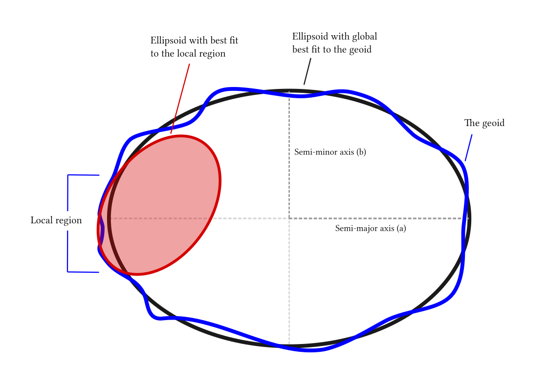
Ellipsoid models
Transformations
Allows you to go back and forth between different CRS
You’ve all done this - convert from cartesian to polar coordiantes (high school math)
Can be 2D or 3D
Most open-source packages depend on PROJ library (https://proj.org/) for CRS support and transformations
Vector
pyproj: Python interface for PROJGeoPandasuses pyproj under the hood for CRS transformations, with support for compound 3D CRS
Raster
gdalwarpwith proper CRS definitions (and available vertical offset grids) should work
Common datasets and CRS definitions
Raster DEMs
ArcticDEM/REMA/EarthDEM products from PGC
These are distributed as 2D projected CRS (EPSG:3031 or EPSG:3413), without a vertical datum definition
Elevation values are “height above the WGS84 ellipsoid” - but no details about specific realization used by vendor (Maxar) providing source stereo imagery
Most of the Maxar data were acquired and delivered after 2008, so should be using more modern realizations of ITRF (2008, 2014, 2020), which are similar
Can likely assume ITRF2014 for most of the available DEM products
Can use custom WKT2 definintions for these 3D CRS:
Antarctica: plugins
/pgc /plugin /ITRF2014 _3031 .wkt
Copernicus 30 m DEM
EPSG:9518 (WGS84 + EGM2008)
Point clouds and altimetry
3DEP lidar
NAD83(2011) horizontal with NAVD88 vertical datum
Projection is Local UTM Zone
EPSG:6339+5703 (example for UTM Zone 10N with NAVD88 datum, https://
epsg .io /6339) Note: this is not the same as EPSG:32610 (WGS84) or EPSG:26910 (NAD83), because we are using NAD83(2011) realization
WA DNR
EPSG:2926+5703 (WA state plane N)
EPSG:2927+5703 (WA state plane S)
NAVD88 model should be geoid2012 (I think, need to confirm)
Always check your dataset metadata!
gdalinfoReview documentation, lidar reports, etc.
Testing and validation
vdatum (https://
cs2cs
echo -120.4 48.6 1400 | PROJ_DEBUG=2 PROJ_NETWORK=ON cs2cs -f "%.3f" -r epsg:7912 epsg:2927+5703
projinfo
projinfo -s EPSG:7912 -t EPSG:2927+5703 -o PROJ --hide-ballpark --spatial-test intersects
    Candidate operations found: 5
-------------------------------------
Operation No. 1:
unknown id, Inverse of Conversion from ITRF2014 (geocentric) to ITRF2014 (geog3D) + ITRF2014 to NAD83(2011) (1) + Inverse of Conversion from NAD83(2011) (geog3D) to NAD83(2011) (geocentric) + NAD83(2011) to NAVD88 height (3) + Inver
se of NAD83(HARN) to NAD83(2011) (NADCON5, CONUS) + SPCS83 Washington South zone (US Survey feet), 0.105 m, United States (USA) - CONUS onshore - Alabama; Arizona; Arkansas; California; Colorado; Connecticut; Delaware; Florida; Geor
gia; Idaho; Illinois; Indiana; Iowa; Kansas; Kentucky; Louisiana; Maine; Maryland; Massachusetts; Michigan; Minnesota; Mississippi; Missouri; Montana; Nebraska; Nevada; New Hampshire; New Jersey; New Mexico; New York; North Carolina
; North Dakota; Ohio; Oklahoma; Oregon; Pennsylvania; Rhode Island; South Carolina; South Dakota; Tennessee; Texas; Utah; Vermont; Virginia; Washington; West Virginia; Wisconsin; Wyoming.
PROJ string:
+proj=pipeline
  +step +proj=axisswap +order=2,1
  +step +proj=unitconvert +xy_in=deg +xy_out=rad
  +step +proj=cart +ellps=GRS80
  +step +proj=helmert +x=1.0053 +y=-1.90921 +z=-0.54157 +rx=0.02678138
        +ry=-0.00042027 +rz=0.01093206 +s=0.00036891 +dx=0.00079 +dy=-0.0006
        +dz=-0.00144 +drx=6.667e-05 +dry=-0.00075744 +drz=-5.133e-05
        +ds=-7.201e-05 +t_epoch=2010 +convention=coordinate_frame
  +step +inv +proj=cart +ellps=GRS80
  +step +inv +proj=vgridshift +grids=us_noaa_g2018u0.tif +multiplier=1
  +step +inv +proj=gridshift +no_z_transform
        +grids=us_noaa_nadcon5_nad83_2007_nad83_2011_conus.tif
  +step +inv +proj=gridshift +no_z_transform
        +grids=us_noaa_nadcon5_nad83_fbn_nad83_2007_conus.tif
  +step +inv +proj=gridshift +no_z_transform
        +grids=us_noaa_nadcon5_nad83_harn_nad83_fbn_conus.tif
  +step +proj=lcc +lat_0=45.3333333333333 +lon_0=-120.5 +lat_1=47.3333333333333
        +lat_2=45.8333333333333 +x_0=500000.0001016 +y_0=0 +ellps=GRS80
  +step +proj=unitconvert +xy_in=m +xy_out=us-ft
Note the 0.105 m uncertainty
Gotchas and other notes
There is no perfect transformation approach, and all transformations have some uncertainty
There are many possible ways to go from one CRS to another, the PROJ pipelines allow you to control this
Many CRS (esp compound or 3D CRS) don’t have EPSG codes - you can define the CRS with machine-readable, well-known text (use WKT2)