Digital Glacier Time Machine
Read the paper in Remote Sensing of Environment: Historical Structure from Motion (HSfM): Automated processing of historical aerial photographs for long-term topographic change analysis
Background and Motivation
Glacier retreat is iconic evidence of climate change (Figure 1). Despite representing only ~1% of the Earth’s total freshwater ice reservoirs, mountain glaciers currently contribute an equivalent amount of melt water to that from Antarctica and Greenland combined (Gardner et al., 2013). The consequences for societies living downstream of glaciers are serious, including coastal inundation and sea level rise, loss of critical water resources, and damage to ecological resources. Despite these significant socioeconomic and political implications, less than 1% of mountain glaciers are actively measured in North America.
The Digital Glacier Time Machine (DGTM) project aims to quantify the decadal evolution of glacier mass change for all glaciers in the western U.S. during the past ~70 years. To accomplish this, we create new data sets through innovative image processing and quantitative analysis techniques. The three main objectives of the project are to:
- Develop automated workflows to systematically extract quantitative information from thousands of previously unprocessed historical aerial images (Knuth et al.)
- Integrate historical data with modern satellite and field observations (e.g., drones, laser scanners) to study the decadal evolution of volume and mass change for every glacier in the western U.S (Figure 3).
- Assess regional glacier response to observed climate change and reduce uncertainty for future model projections.
Data and Methods
Historical Aerial Photographs (1950s-1990s)
From the 1950s to 1990s, the USGS North American Glacier Aerial Photography (NAGAP) program collected over 100,000 overlapping, high-resolution photos of glaciers in the western U.S. and Alaska (Figure 4) (Post, 1995). Additional photographs are available from state and federal archives.
Historical Image Pre-Processing
Images scanned from historical photographs must be standardized prior to processing using Structure from Motion (SfM) software (Figure 5). We developed the Historical Image PreProcessing (HIPP) software to automate image retrieval from public archives and streamline the standardization process (Knuth et al.).
Historical Structure from Motion
We leverage modern photogrammetry methods and state of the art DEM co-registration techniques in the HSfM software to automate processing historical photographs into accurately positioned DEMs and measure 3D landscape change (Figure 6) (Knuth et al.).
Recent Results
We have automated processing of multiple dataset configurations, including individual flightlines over the same site collected on many dates, multiple separate flightlines collected over multiple dates, and large sets of images collected on a single date (Figure 7).
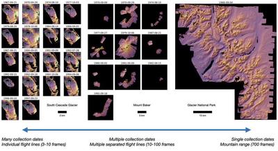
Figure 1. Illustration of the many dataset configurations handled by the HSfM software. Each individual DEM is separately co-registered to a reference surface to obtain absolute positional accuracy.
Funding
UW Innovation Award
- David Shean (Co-PI)
- Knut Christianson (Co-PI)
- Michelle Koutnik (Co-PI)
USGS CESU Agreement # #G19AC00433
Team
UW: David Shean (PI), Friedrich Knuth (PhD student), Eli Schwat (PhD student), Shashank Bhushan (PhD student)
Collaborators: Shad O’Neel (US Army Corps), Caitlyn Florentine (USGS), Chris McNeil (USGS), Amaury Dehecq (IGE), Oleg Alexandrov (NASA)
Publications
Knuth et al. An automated Structure from Motion (SfM) pipeline for historical aerial photographs with applications for quantitative glacier and geomorphic change analysis. https://doi.org/10.1016/j.rse.2022.113379.
Presentations
Knuth, F., Shean, D., Schwat, E. and Bhushan, S., 2021. 70 years of high-resolution glacier surface elevation records derived from historical aerial photography across Western North America. https://agu2021fallmeeting-agu.ipostersessions.com/default.aspx?s=3D-5A-78-CD-B3-98-02-9D-7A-B8-E5-A2-EC-CA-93-D7
Knuth, F., Shean, D. and Bhushan, S., 2021, April. Historical Structure From Motion (HSfM): Automated production of high-resolution DEMs from historical aerial photography for long-term geodetic change analysis. In EGU General Assembly Conference Abstracts (pp. EGU21-13196). https://meetingorganizer.copernicus.org/EGU21/EGU21-13196.html
Press
Groundbreaking cloud computing at UW measures how glaciers respond to climate change — and how to prepare the millions who rely on their life-supporting waters, UW-IT Connect Newsletter, 2019 - Ignacio Lobos https://www.washington.edu/uwit/partnerships-2019/cloud-computing-climate-change/
UW Innovation Award funds digital glacier time machine, UW-IT Connect Newsletter, 2018 - Ignacio Lobos https://www.ce.washington.edu/news/article/2018-03-08/uw-innovation-award-funds-digital-glacier-time-machine
Related Code
HIPP
Software to pre-process scanned historical images for Structure from Motion (SfM) surface reconstruction and photogrammetric analysis https://github.com/friedrichknuth/hipp
HSfM
Software for automated SfM processing of historical aerial photographs for land surface elevation change detection and quantitative analysis. https://github.com/friedrichknuth/hsfm
Dataset Releases
All scanned images and initial metadata used in this study are publicly available from the NSF Arctic Data Center and USGS EarthExplorer archives. The reference DEM data are publicly available as described in Section 3.5. The HSfM DEMs and orthoimage mosaics prepared for this manuscript are available in a Zenodo dataset archive with doi: 10.5281/zenodo.7297154. Open-source repositories for the Historical Image Pre-Processing (HIPP, doi: 10.5281/zenodo.5510876) and Historical Structure from Motion (HSfM, doi: 10.5281/zenodo.5510870) packages are publicly available on Github with MIT license, documentation, and Jupyter notebook examples.
References
Fountain, A. G., Krimmel, R. M., Trabant, D., & Geological Survey (U.S.). (1997). A strategy for monitoring glaciers. Washington]; Denver, CO: U.S. G.P.O. ; Free on applications to the U.S. Geological Survey, Information Services.
Fountain, A. G., Hoffman, M. J., Granshaw, F., & Riedel, J. (2009). The ’benchmark glacier’ concept–does it work? Lessons from the North Cascade Range, USA. Annals of Glaciology, 50(50), 163–168.
Gardner, A. S., Moholdt, G., Cogley, J. G., Wouters, B., Arendt, A. A., Wahr, J., … Paul, F. (2013). A Reconciled Estimate of Glacier Contributions to Sea Level Rise: 2003 to 2009. Science, 340(6134), 852–857. https://doi.org/10.1126/science.1234532
Harper, J. T., 1993. Glacier Terminus Fluctuations on Mount Baker, Washington, U.S.A., 1940-1990, and Climatic Variations. Arctic and Alpine Research 25(4), 332-340.
Post, A. (1995). Annual aerial photography of glaciers in northwest North America: How it all began and its golden age. Physical Geography, 16(1), 15–26.
Riedel, J., & Larrabee, M. (2011). North Cascades National Park Complex Glacier Mass Balance Monitoring Annual Report, Water Year 2009: North Coast and Cascades Network (Natural Resource Technical Report NPS/NCCN/NRTR No. 2011/483). Fort Collins, Colorado: National Park Service.
Riedel, J. L., Wilson, S., Baccus, W., Larrabee, M., Fudge, T. J., & Fountain, A. (2015). Glacier status and contribution to streamflow in the Olympic Mountains, Washington, USA. Journal of Glaciology, 61(225), 8–16. https://doi.org/10.3189/2015JoG14J138
Seitz, S. M., Curless, B., Diebel, J., Scharstein, D., & Szeliski, R. (2006). A comparison and evaluation of multi-view stereo reconstruction algorithms. In Computer vision and pattern recognition, 2006 IEEE Computer Society Conference on (Vol. 1, pp. 519–528)
Shean, D. E., Alexandrov, O., Moratto, Z. M., Smith, B. E., Joughin, I. R., Porter, C., & Morin, P. (2016). An automated, open-source pipeline for mass production of digital elevation models (DEMs) from very-high-resolution commercial stereo satellite imagery. ISPRS Journal of Photogrammetry and Remote Sensing, 116, 101–117, doi:10.1016/j.isprsjprs.2016.03.012.
Van Beusekom, A. E., O’Neel, S. R., March, R. S., Sass, L. C., & Cox, L. H. (2010). Re-analysis of Alaskan benchmark glacier mass-balance data using the index method. US Geological Survey Scientific Investigations Report, 5247, 16.
Vaughan, D. G., Comiso, J. C., Allison, I., Carrasco, J., Kaser, G., Kwok, R., … Zhang, T. (2014). Observations: Cryosphere. In Intergovernmental Panel on Climate Change (Ed.), Climate Change 2013: The Physical Science Basis. Contribution of Working Group I to the Fifth Assessment Report of the Intergovernmental Panel on Climate Change (pp. 317–382). Cambridge: Cambridge University Press.
Friedrich Knuth
PhD student
Friedrich Knuth is a PhD student in the UW Hydrology and Hydrodynamics Program. His current research focuses on reconstructing the 3D evolution of mountain glaciers in response to climate forcing, using historical aerial photography and satellite imagery collected over the past century.